September 30, 2026
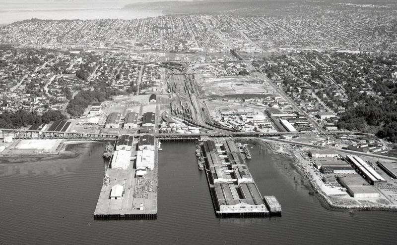
In 1976 with a handshake and a $15 million check, Terminal 91 — all 198 acres and its two half-mile long piers — came home to its original owner, the Port of Seattle. June 30th marked the 50 anniversary of this happy reunion.
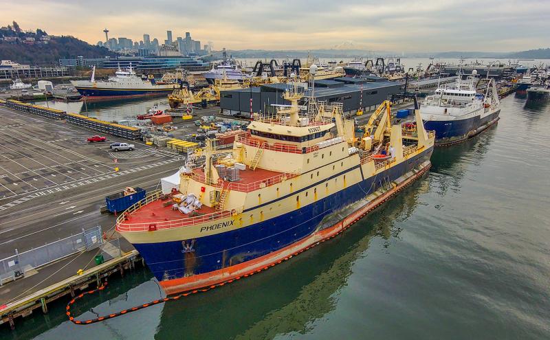
Today Terminal 91 is home to the Smith Cove Cruise Terminal and home port for many of the larger fishing ships that ply Alaskan waters, harvesting yummy aquatic treasures. But the throngs of passengers and crew that pass from dock to vessel might be unaware that they are following in the same bootsteps of generations of service men and women who crossed those very same piers onto supply vessels and warships from World War II through the height of the Cold War.
So, how did this come about? Well, dear reader, pull up a metaphorical chair and hear the tale.
Smith Cove and the railroads
Terminal 91 is located on the north side of Elliott Bay in Seattle, an area with several different names over history. Coast Salish people knew this inlet well, including a creek known as T³E'kEp (or túqap/teqep) in Lushootseed, meaning “a blocked bottom” or “an aerial duck net,” referring to duck snares set between Elliott Bay and Lake Union.
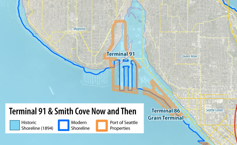
Above: Map Showing the 1894 shoreline and the current shoreline and the location of Today’s Terminal 91. Source: Port of Seattle
European settlement of the area began in the early 1850s when the Denny Party explored the Interbay tidelands between Magnolia and Queen Anne Hill. Dr. Henry Smith claimed land in the area, anticipating its future value for docks, rail, and canal development. While he waited for the trains to arrive, he built a medical practice, farmed the land, and became known for his (later disputed) translation of Chief Seattle's 1854 speech.
Decades later, Smith’s predictions proved accurate. In 1893, James J. Hill picked Smith Cove as the ending point for his Great Northern Railroad. Hill built the first large piers on the site for the lucrative silk trade with Japan, creating what was later dubbed the “new silk road” with rail service from the East Coast to Japan and China with connections to a steamship based at Smith Cove that transported passengers and cargo.
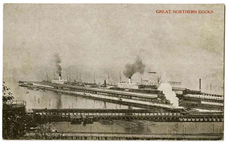
Above: Postcard of the Great Northern Docks on Smith Cove (Today’s Terminal 91), 1905. Post Card’s Caption on the Back: “At these docks the great Steamboats which run between Seattle and Japan, China and other Trans-Pacific countries load and unload their immense cargoes.” Photo courtesy Seattle Public Library via Public Domain.
Establishing a port
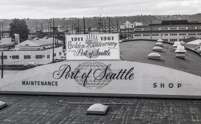
On September 5, 1911, the voters of King County voted to establish the Port of Seattle to provide public direction for waterfront development. One of its first key projects included new international shipping piers at Smith Cove.
The Port purchased the property from the Great Northern Railway. Between 1911 and 1916, the construction of the Lake Washington Ship Canal reshaped the tidelands, and dredged fill was used to reclaim roughly 150 acres at Smith Cove. On this reclaimed land, the Port built new piers that at the time were the longest in the world.
World War II and the naval station at Smith Cove
Beginning in the late 1930s, the war in Europe and Asia led to an increase in maritime activities and a boom in Puget Sound's shipping and shipbuilding industry. As the war escalated and the United States prepared to enter the war, military activity on the Sound also increased.
In anticipation, the U.S. Navy took over the Smith Cove piers in March 1941. While it initially began condemnation proceedings to acquire the piers without compensation, the Navy ultimately gave in to objections from the Port and paid more than $3,000,000 for the piers and their facilities, spending a total of $20,000,000 to purchase land from both the Port and private landowners.
In 1944 the Navy renamed all the piers in Seattle’s harbor — which until then were a jumble of names and numbers — into uniform numbered piers, beginning with Pier 1 in West Seattle and circling counterclockwise around Elliott Bay and ending with Piers 90 and 91 at Smith Cove.
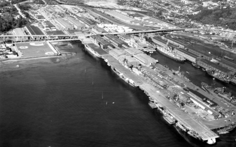
Above: Deactivated warships at Terminal 91 1946, April 1946. On the near side of the pier are the carriers Essex (CV-9); Bonhomme Richard (CV-31) and Bunker Hill (CV-17). On the far side of the pier is the carrier Ticonderoga (CV-14) and the battleships Indiana (BB-58) and Alabama (BB-60). Photo courtesy of the Naval History and Heritage Command via Public Domain.
For the next 34 years, Terminal 91 became known as the Seattle Naval Supply Depot and was officially designated by the military as the Naval Supply Center, Puget Sound Seattle Division, supporting operations in the Pacific Theater and Alaska. The piers hosted warships, personnel transport vessels, and cargo vessels both during and after the war.
The Naval Station Supply Depot consisted of 253 acres of developed land, including 53 acres of covered storage space and 22.5 acres of uncovered storage for the Naval Supply Depot operations, including several cold storage facilities. Additional facilities included:
- 20 barracks for enlisted men
- two barracks for Women Accepted for Volunteer Emergency Service (WAVES)
- separate mess halls
- recreation halls
- an indoor swimming pool
- a recreation field
- a hospital
- a cafeteria for civilian workers
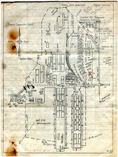
Above: Map of the Naval Supply Depot in the 1950s during the Korean War. Photo courtesy Ed Weiss on Seattle History Facebook page.
Post-World War II activities
Although activity at the Naval Supply Depot was dramatically scaled back after World War II, it continued to operate in various capacities in support of all military service branches. During the Korean and Vietnam wars, supply freight movement increased again with cargo shipment activity during the Vietnam War, reaching its highest since World War II.
However, after the Naval Supply Center was established in Bremerton on October 2, 1967, the U. S. Navy began transferring most of these operations to the new facility and in March of 1970 the Navy announced the closure of the facilities at Piers 90/91.
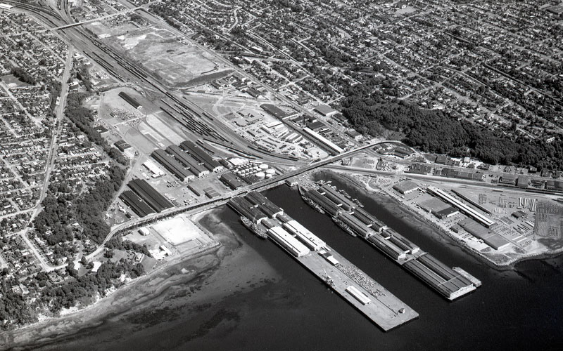
Above: An aerial view of the Port of Seattle’s Terminal 91 taken on July 28, 1976. Three decades after serving as a massive World War II naval base, the facility is captured here during its transition into a multi-use commercial and industrial hub, showing the long parallel piers, extensive railyards, and surrounding Magnolia and Queen Anne neighborhoods. Source: Port of Seattle archives.
Returning home: six years' hard bargaining
Although the Navy identified the property as surplus for disposal within a year, negotiations with the Port for the purchase of the largest portion of the property and piers took much longer. In the meantime, the Port and other parties leased buildings and facilities at the terminals for various activities.
Beginning in 1970, Richard D. Mohn, Port Assistant General Manager, worked with the Navy to return the facility to the Port. During the next six years, the Port of Seattle became the licensed operator for the complex and took over management of cargo across the piers as the negotiations continued.
Finally, in 1976, an agreement was reached. The final purchase price to return the piers and much of the inland areas called uplands to the Port was $15,355,000 ($90.4 million in 2026), slightly more than the symbolic one dollar offer made in 1970 by Port General Manager J. Eldon Opheim when the property was first listed as surplus.
The General Services Administration (GSA) had originally appraised the complex at about $25 million. The final agreed price was also contingent on the Port of Seattle transferring Piers 36 and 37 properties — along Seattle’s central waterfront — to the Coast Guard, allowing the Coast Guard to retain its Northwest headquarters, where its cutters and icebreakers still berth today.
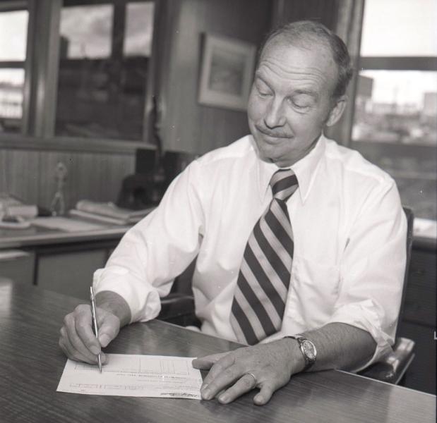
Above: John Rooth, former Port auditor, signed the check for presentation to the General Services Administration, 1976. Source: Port of Seattle archives
Handshake and a check at the chamber of commerce
On June 30, 1976, the Seattle Chamber of Commerce held a signing event marking the completion of the transfer
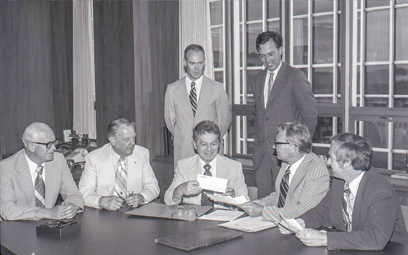
Above: On June 30, 1976, Richard D. Mohn, former Assistant General Manager hands over the Port’s check to the GSA in a joint sponsored ceremony and reception, as the Seattle Chamber of Commerce and the Port marked the official purchase and transfer of title of the huge complex to the Port from the U.S. Navy. It was the largest single waterfront property acquisition since the Port’s founding in in 1911. Source: Port of Seattle archives
Rear Adm. Chester Richmond, commandant of the 13th Coast Guard District, accepted the title to Piers 36 and 37 from the Port. He expressed appreciation for the Port’s actions that allowed the retention of the Coast Guards fleet in Seattle.
Rear Adm. James Murray, commandant of the 13th Naval District, welcomed the Port of Seattle as his new neighbor, gently reminding the Port Commission that the transfer of the title did not include his big “house on the hill” or the Officers Club, both of which would remain Navy property. Today the “big house on the hill” is now known as The Admiral’s House, and serves as a picturesque venue for weddings and events.
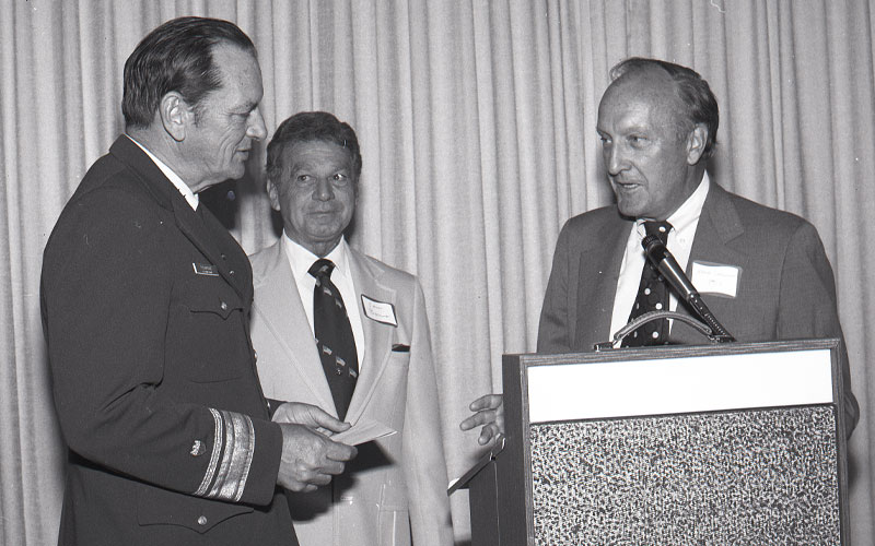
Above: On June 30, 1976, Rear Adm. Chester Richmond, former commandant of the 13th Coast Guard District, accepted title to Pier 36 from Port of Seattle Commissioner Henry T. Simonson while Vern Barnes looks on. Source: Port of Seattle archives
Since then, Terminal 91 has supported commercial fishing, seafood processing, cold storage, auto importing, and starting in 2004, cruise operations at Smith Cove Cruise terminal.
In total, 218 acres were returned to the Port of Seattle, a transfer that remains the largest single land acquisition on the waterfront in Port history. This didn’t include areas that were retained by the military and eventually became the Washington State National Guard Armory in Interbay.
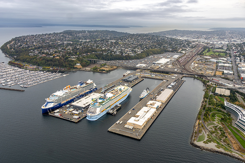
Above: Modern Terminal 91 with the Celebrity Edge and Royal Caribbean Voyager of the Seas at berth at Smith Cove Cruise Terminal on September 11, 2026. Source: Port of Seattle archives.
What remains from the U.S. Navy at Terminal 91?
Terminal 91 has changed dramatically over the past 50 years, but several Navy era buildings remain. Look closely and you’ll spot remnants of the 1942-1976 Naval Station.
Remaining buildings:
W-40 Storage Facility / Independent Packers Corporation Building, 1945
Originally built as an oil and paint storehouse with rail served cargo doors. Part of the southern portion was removed around 2005–2007 to make way for cruise traffic. Today, it is leased to Lineage, subleased to Independent Packers Corp, and is used for seafood processing operations
W-39 Cold Storage Building /City Ice, Building, 1942
Constructed early in the Navy’s development of the Supply Depot. Recently decommissioned and returned to the Port, it’s now slated for demolition
M-28 Garage / Seafood Processing Building, 1925
Built even before the Navy arrived, originally serving as a garage during the site’s refinery era and was repeatedly renovated. The Port later renovated part of it for United States Department of Agriculture (USDA) meat inspection. Now slated for demolition
M-21 (sometimes referred to as M-19A) Office, circa 1929
Another pre-Navy structure, built for the former refinery and fuel farm. The fuel farm has been dismantled, and the building remains in use today
M-19 Tank Farm Boiler / Shop Building, 1925
Constructed to support the petroleum facilities once operated by the Texas Oil Company. Used by several companies after the Navy era. Now slated for demolition following cleanup of the tank farm
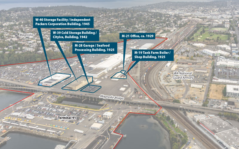
Above: An aerial infographic map of the Port of Seattle's Terminal 91, with property boundaries outlined in red to highlight remaining Navy-era historic buildings. Blue outlines and text labels identify four specific structures: the W-40 Storage Facility (1945), W-39 Cold Storage Building (1942), M-28 Garage (1925), and the M-21 Office / M-19 Tank Farm Boiler and Shop Building (ca. 1925–1929). The Magnolia Bridge spans horizontally across the foreground container lots and parking areas. To the right, active rail lines run parallel to the WA National Guard Armory, while the residential hillside of the Magnolia neighborhood rises in the background. Source: Port of Seattle archives.
Seattle military-era facilities decommissioning
The 1970s marked a shift in Seattle's military facility landscape. As the Vietnam War ended and military needs shifted, the Department of Defense drastically reduced its footprint in the city. Much of the prime real estate once occupied by the military was handed over to the City of Seattle and the Port of Seattle, making up many of the parks and open spaces enjoyed by the community today.
Major closures included Sand Point Naval Air Station (now Magnuson Park), Fort Lawton (now Discovery Park), and The Navy Supply Depot (now Terminal 91).
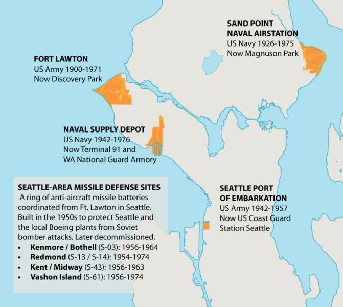
Above: An informational map highlighting historic Cold War-era military sites in the Seattle area and their modern uses. Five locations are highlighted in orange across a simplified coastal map: Fort Lawton (US Army 1900–1971, now Discovery Park), Sand Point Naval Airstation (US Navy 1926–1975, now Magnuson Park), Naval Supply Depot (US Navy 1942–1976, now Terminal 91 and WA National Guard Armory), and Seattle Port of Embarkation (US Army 1942–1957, now US Coast Guard Station Seattle). A text panel describes a 1950s ring of anti-aircraft missile defense sites built to protect Seattle and Boeing plants from Soviet attacks, listing historical sites in Kenmore/Bothell, Redmond, Kent/Midway, and Vashon Island. Source: Created by the Port of Seattle using Port and City of Seattle GIS Data with cross checking from US military and historic maps of the city.
Sources and additional reading:
- Port of Seattle Reporter, August 1976 issue
- Port of Seattle North Bay Project DEIS Historic and Cultural Resources
- Seattle Waterfront History Chapter 1 by Paul Dorpat, Seattle Now and Then
- Dzidzilalich (Little Crossing Over Place), by Jennifer Ott
- Seattle Neighborhoods: Interbay — Thumbnail History, by David Wilma
Subscribe to Connections for news and updates from the Port of Seattle and SEA Airport.