
Learn more about the Port's completed cleanup projects below. Contact information for each project is provided.
Learn more about the Port's completed cleanup projects below. Contact information for each project is provided.
Terminal 117 (T-117), formerly known as the Malarkey Asphalt Plant, is located at 8700 Dallas Avenue South on the west side of the Duwamish River in South Park. The site has been restored as currently a habitat restoration site and community park now known as Duwamish River People’s Park. The site is adjacent to The Boeing Company and South Park Marina.
The Duwamish Manufacturing Company and Malarkey Asphalt Company operated at the site beginning in 1937. These companies heavily polluted the soil and shoreline of the site and went out of business in 1993. The Port acquired a portion of the property in 1999 with the intent to build a maritime cargo terminal.
In 2003, the US Environmental Protection Agency (EPA) designated the site as an “Early Action” area with the Lower Duwamish Waterway (LDW) Superfund Site due to the significant contamination at the site. PCBs were also found in the adjacent neighborhood streets and yards.
Past operations led to soil, sediment and groundwater contamination. The primary contamination of concern was PCBs. The Site has been fully remediated and is now a habitat restoration site that includes a public access area and park.
The Port and the City of Seattle jointly performed the site cleanup under EPA’s oversight. Following completion of the cleanup, the Port restored 14 acres of critical fish and wildlife habitat along with public shoreline access. This large-scale restoration project supports recovery of the endangered Southern Resident orca population by significantly increasing habitat critical to abundance and health of Chinook salmon.
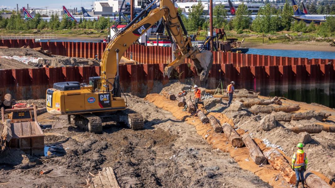
Phase I of the T-117 cleanup – addressing upland soils and in-water sediments –was completed in December 2014. The Phase I cleanup included removal of pavement, derelict structures, and 60,000 tons of soil and sediment. PCB-contaminated soil and sediments were excavated and hauled off-site to a licensed waste landfill. The City of Seattle began Phase II of the environmental cleanup in 2015, including stormwater and street right-of-way improvements in upland areas adjacent to T-117. During construction, steel sheet piling was used to isolate contaminated soil and water from the river.
The Port and the City of Seattle will continue to monitor the effectiveness of the cleanup and to ensure that it remains effective in protecting people and the environment. As of 2025, year 10 monitoring was completed and demonstrated that the remedy is still effective. The site will continue to be monitored as part of the larger Lower Duwamish Waterway Cleanup.
Construction of Duwamish River People's Park was completed 2022.
Joanna Florer | Senior Manager, Environmental Programs | [email protected]
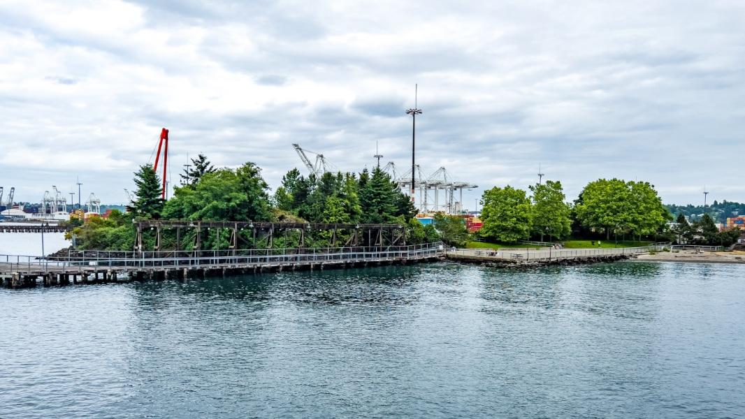
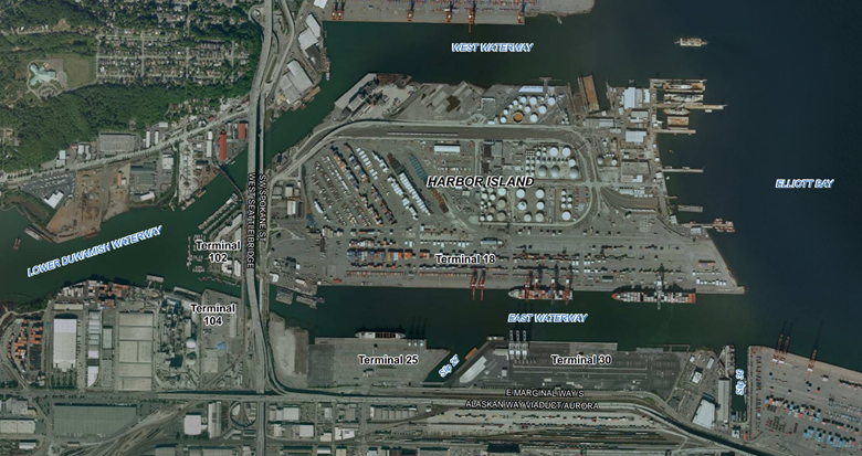
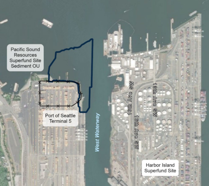
Terminal 5 (T-5) is a 185-acre property at 3443 West Marginal Way Southwest in Seattle, Washington. T-5 is located along the base of the West Seattle on the shoreline of the West Waterway, across from Harbor Island near the terminus of the Lower Duwamish Waterway (LDW). The operational portion of T-5 is currently leased to as an active freight terminal and provides shipping container storage. T-5 also includes a public access area, Jack Block Park, in the northern portion of the property and an inactive consolidated landfill (known as the CEM Landfill) along the western boundary of the terminal. The cleanup portion of the site is known as the Southwest Harbor Project (SWHP).
T-5 overlies former tide flats that have been filled and used for various industrial purposes, including but not limited to railroad yards, wood treatment facilities, steel scrap storage, and a municipal and wood waste landfill. For the purposes of upland cleanup, the SWHP was divided into five Remediation Areas (RAs). RA-1, 2, 3, and 5 were remediated under oversight by the Washington State Department of Ecology (Ecology), while RA-4 was addressed under an agreement with the United States Environmental Protection Agency (EPA). Read about the operational history of each RA.
Soil and groundwater contamination within the SWHP area originated from former industrial operations prior to the redevelopment of T-5.
The various historical operations led to soil and groundwater contamination. As the property owner, the Port led efforts to address contamination at most of the Site. The Port performed this cleanup to ensure protection of human health and prevent sources of contamination from discharging into the West Waterway and Elliott Bay. The engineered environmental controls employed at each RA protect the public, terminal workers, and the environment from being exposed to underlying potentially contaminated material. EPA, rather than the Port, led the cleanup work at RA-4, although the Port performed much of the cleanup work on behalf of EPA.
During the 1990s, the RAs were remediated, through a combination of removing soil with elevated contaminant concentrations, consolidation of subsurface contamination, and installation of engineered environmental controls to manage contaminated soil and groundwater remaining in place. These environmental controls include asphalt covers/caps, ballast covers, and containment systems specific to each RA. Learn more about soil contaminants of concern (COCs) and engineered controls of the individual RAs.
From 2008 to 2011, the Port conducted groundwater monitoring to confirm that the remedial actions completed for each RA were protective of surface water quality for the site as a whole and to confirm the effectiveness of the engineered controls in place to prevent. Groundwater data showed that state cleanup standards were met and Ecology determined that the requirements of the groundwater monitoring plan had been satisfied.
The T-5 is currently in the long-term operation and maintenance phase of the cleanup. The Port’s primary ongoing obligation involves monitoring and maintaining the engineered and institutional controls employed at each RA.
The Port performs semiannual inspections of site pavement caps, drainage, ballast cover areas, fencing, and warning signs for the Ecology-led portions of the SWHP project (RA-1, 2, 3, and 5 and the CEM Landfill). A landfill gas (methane) collection system at the CEM Landfill currently operates in passive mode. The Port recently implemented recommendations to enhance the system’s passive gas extraction. Methane monitoring is conducted monthly.
For the EPA-led portion of the Site (RA-4), the Port performs annual inspection of the intermodal yard and the Jack Block Park Public Access Area. Groundwater monitoring and dense non-aqueous phase liquid gauging and recovery is conducted quarterly.
Jalyn Buckley | Environmental Management Specialist | [email protected]
For more information, visit Ecology’s Southwest Harbor Project webpage.
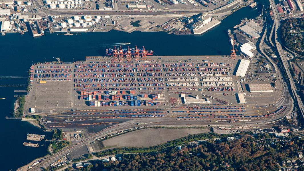
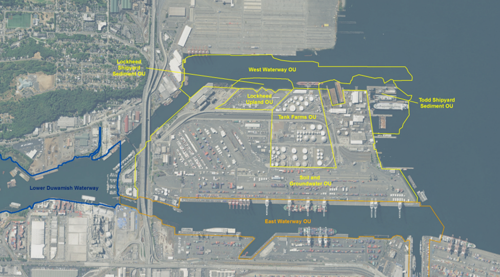
Terminal 18 (T-18) is located on the eastern side of Harbor Island at 1050 SW Spokane St, Seattle, Washington, and makes up a large portion of the Harbor Island Superfund Site Cleanup Operable Unit (OU) 01 – Soil and Groundwater (S&G-OU1 or just OU1). It is bordered by East Waterway to the east and Elliott Bay to the north and spans approximately 106-acres of Harbor Island. T-18 is zoned for industrial use and is covered by an asphalt cap. The site is currently leased for shipping container storage, rail lines, roadways, and administrative buildings.
Harbor Island was one of the first sites that EPA listed as a Superfund site in 1983. Harbor Island was divided into seven OUs, with OU1 containing T-18. As part of the cleanup work, contaminated soils were removed in 1996. The Port acquired an additional 90-acres of the island in 2003 and expanded T-18. The expanded area contained contaminated soil that the Port excavated and capped completing the cleanup in 2011.
Contaminants at the site included lead, arsenic, and petroleum hydrocarbons. A smelter used on-site until 1984 was identified as a source of high metal concentrations on the property. Spills and leaks from petroleum tanks from historical operations led to localized soil contamination.
As the property owner, the Port led efforts to address contamination at the site, along with several other parties represented by the Harbor Island Soil & Groundwater OU Group.
Contaminated soil hot spots that exceeded cleanup goals were removed, treated on-site, or capped. Following the cleanup, a long-term groundwater monitoring program was implemented.
Active cleanup work has been completed and the Site is currently in long-term groundwater monitoring, which is expected to continue through 2035 along with five-year reviews. Although contamination has been found in some wells, it has remained localized and stable since 2015.
Brick Spangler | Senior Environmental Program Manager | [email protected]
Visit EPA’s Harbor Island Superfund Cleanup page for more information and updates on the East Waterway cleanup.
Terminal 10 (T-10) is located on the western side of Harbor Island at 2929 16th Ave SW, Seattle, Washington. T-10 is sometimes referred to as Lockheed Yard 1 or Lockheed Upland. T-10 consists of Harbor Island Superfund Site Operable Unit (OU) 03 – Lockheed Upland (LU-OU3 or OU3) and the adjacent Lockheed Shipyard Sediment OU (LSS-OU7 or OU7).
Harbor Island was constructed in 1909 by the Puget Sound Bridge and Dredging Company for the purpose of commercial and industrial ocean and rail transport operations. Historic use on the site included bulk fuel storage, secondary lead smelting, lead fabrication, ship building, and metal plating. Puget Sound Bridge and Drydock began operations at Yard 1 in the early 20th century.
Harbor Island was one of the first sites that EPA listed as a Superfund site in 1983. Harbor Island was divided into seven OUs, with OUs 3 and 7 containing T-10. Lockheed Martin led the cleanup work for this site, entered a Consent Order with EPA for OU3 in 1990 and for OU7 in 1996.
 Contamination Issue
Historical industrial practices (ship building, dry dock ship repairs, vessel sandblasting, and painting) at this former shipyard resulted in contamination of soil and sediment. The contaminants of concern at upland OU3 included petroleum, copper, and tetrachloroethylene (PCE). The contaminants of concern at sediment OU7 included hazardous substances associated with shipbuilding and maintenance such as arsenic, copper, lead, mercury, zinc, polyaromatic hydrocarbons, and polychlorinated biphenyls (PCBs).
The cleanup was completed by Lockheed Martin. As the current property owner of T-10 and pursuant to an agreement with Lockheed Martin, the Port oversees ongoing cap maintenance and groundwater monitoring.
The cleanup for OU3 was completed in 1995. The selected remedy for OU3 included excavation and offsite treatment/disposal of contaminated hot spot soils. It also included an asphalt or reinforced concrete cap for soil contamination that exceeded cleanup goals but did not warrant removal, and it required groundwater monitoring for 30 years starting in 2005.
The cleanup for OU7 was completed in 2005. The selected remedy for OU7 included demolition of the existing pier, removal of 6,000 creosote-coated pilings, dredging and offsite disposal of contaminated sediments in the open channel area, and a sediment cap in the nearshore area. It was specified that the sediment cap must include habitat-friendly substrate.
T-10 and its adjacent sediments are currently in long-term monitoring. Five-year reviews are still being conducted on the site.
Groundwater monitoring at OU3 has shown exceedances of applicable cleanup levels for copper and PCEs, but these exceedances have remained stable and localized. OU3 has not shown signs of recontamination of the sediment cap at OU7.
Brick Spangler | Senior Environmental Program Manager | [email protected]
Visit EPA’s Harbor Island Superfund Cleanup page for more information.
Lockheed Yard 2 (Yard 2) encompasses approximately 40 acres, with approximately 24.5-acres of uplands and 15.5 acres of submerged sediments. It is located on the eastern side of Terminal 5 at 2330 SW Florida St. at what is now Jack Block Park.
Yard 2 was part of Elliott Bay’s intertidal zone until it was filled in the 1930s. Puget Sound Bridge & Dredging Company began operations at this site in 1943 to build ships for the U.S. Navy. Lockheed Shipbuilding Company then operated the site from until1959 until 1986. It was purchased by the Port in 1992.
 Contamination Issue
Historical industrial practices including ship building, dry dock ship repairs, vessel sandblasting, and painting resulted in contamination of soil and sediment. Contaminants of concern in the sediment portion included polyaromatic hydrocarbons, polychlorinated biphenyls, and metals such as arsenic, copper, lead, and mercury.
Lockheed Martin completed the cleanup. As the current owner of the Site and pursuant to an agreement with Lockheed Martin, the Port now maintains the sediment cap and overall site.
The cleanup began in 2018 and was completed in 2020. Approximately 167,000 cubic yards of contaminated material were dredged and disposed of offsite, and creosote-treated pilings were removed. A sediment cap of clean material was placed over the dredged area.
Yard 2 is now in long-term monitoring with regular five-year reviews.
Brick Spangler | Senior Environmental Program Manager | [email protected]
Please visit EPA’s case summary for more information.