Menu Port of Seattle Logo - Home

Noise Abatement Procedures and Flight Patterns

Noise abatement flight procedures for jet aircraft are specific flight headings and altitudes designed to minimize noise over surrounding communities. The FAA, in cooperation with the SEA Airport and local communities, established the procedures to take advantage of existing geographical and compatible land use conditions wherever possible.

Although the FAA has sole authority over aircraft in flight, the SEA has taken the lead responsibility for monitoring and reporting air traffic activities in regard to noise abatement procedures. This information is used to track trends and identify problem areas. The FAA can direct aircraft to deviate from the noise abatement procedures for a variety of reasons, including weather, traffic safety, and aircraft performance. Propeller aircraft, being smaller and slower, cannot fly within the noise abatement corridors with jet aircraft and are allowed to deviate from the jet noise abatement flight procedures.

Whether an aircraft departs to the north (north flow) or the south (south flow) depends on wind conditions. Aircraft depart heading into the wind. In the Puget Sound region, winds tend to flow out of the south during cloudy, overcast days necessitating departures to the south. During clear weather, winds tend to flow out of the north, necessitating departures to the north.
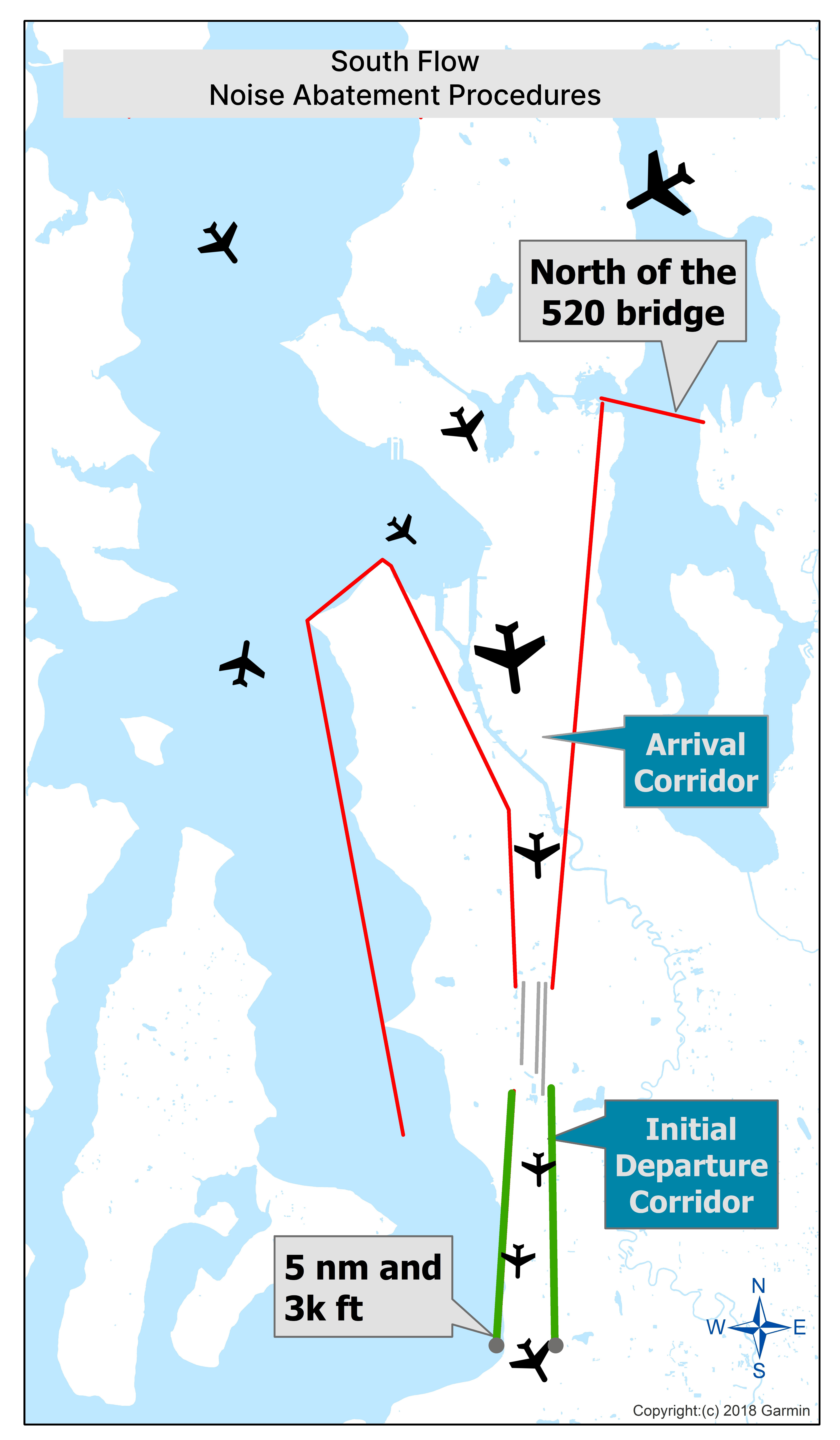
Noise Abatement Procedures for Jets - South Flow

Arriving 

Jet aircraft from the west fly north of West Seattle and then turn south to approach SEA Airport, preferably over Elliott Bay. From the east, arriving jet aircraft stay north of the 520 Bridge and then turn south to approach SEA Airport.

Departing 

Jet aircraft are confined to a narrow corridor and can initiate a turn once they reach 5 nautical miles and at least 3,000 feet in altitude.

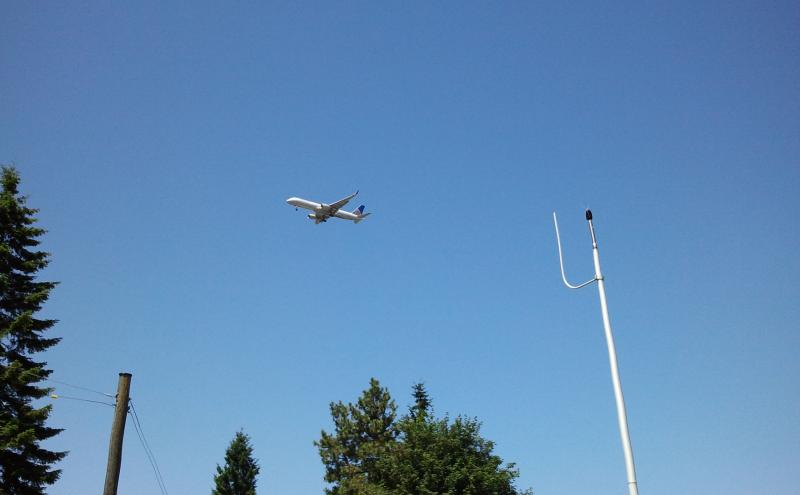
aircraft departing to the south and entering seatac airport from the north


.

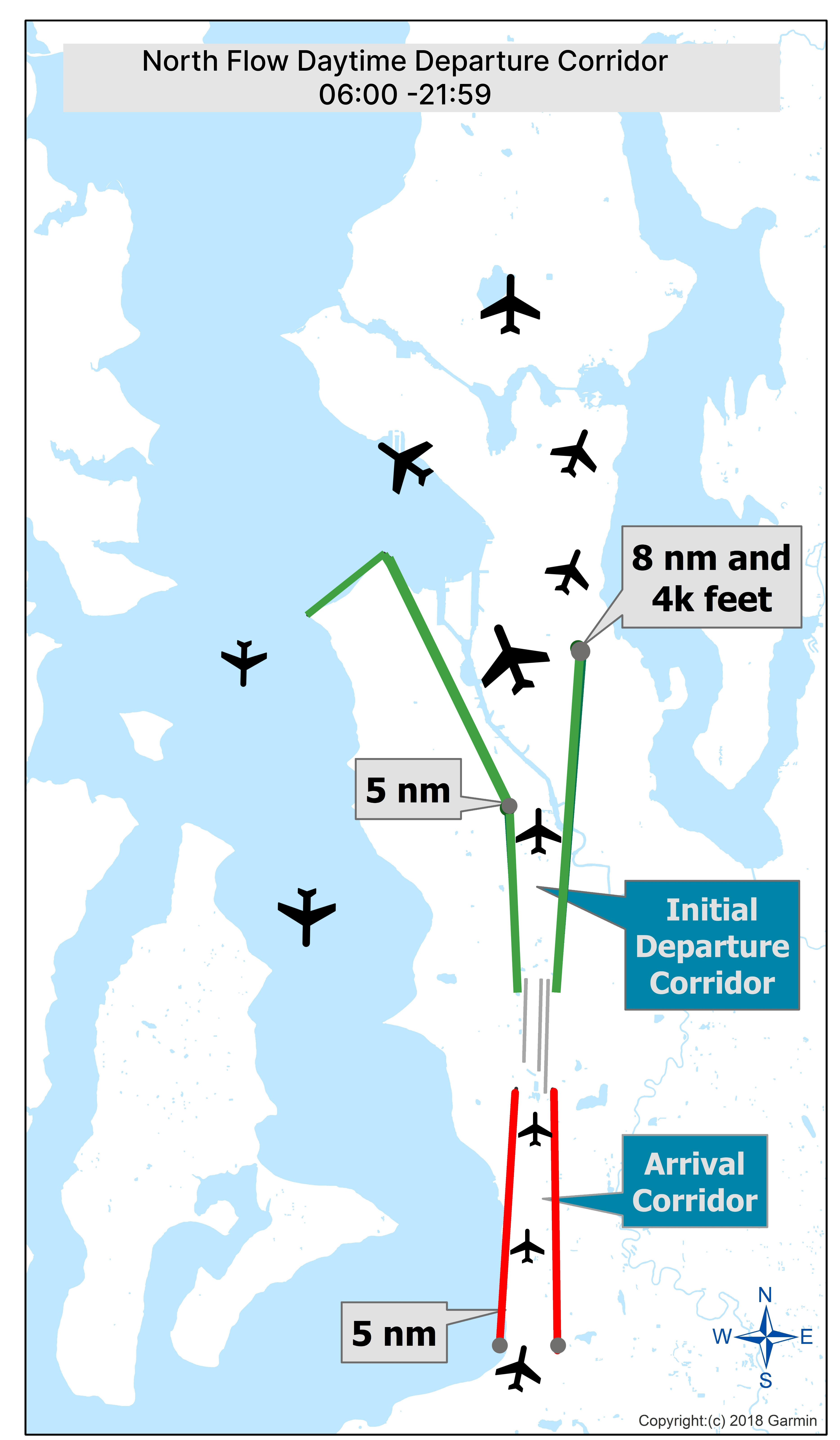
Noise Abatement Procedures for Jets - North Flow Daytime

North flow: daytime between 6:00 a.m. – 10:00 p.m.

North Flows Arrivals (red) and Departures (green)

A map titled “North Flow Daytime Departure Corridor 06:00–21:59” showing aircraft flight paths over a coastal region with water and land areas. Multiple black airplane icons indicate example aircraft positions. Two green lines mark the initial northbound departure corridor, labeled “Initial Departure Corridor,” with callouts reading “5 nm” and “8 nm and 4k feet.” A red line marks the southbound arrival corridor, labeled “Arrival Corridor,” with another “5 nm” callout near the bottom. A compass rose indicating north, south, east, and west is in the lower right corner. The map is credited to Garmin (2018).Arriving jet aircraft execute final turns before entering the narrow 5 nautical mile (nm) corridor extending from the runways.
Departing jet aircraft are confined to a narrow corridor and can turn east once they reach 8 nautical miles and at least 4,000 feet in altitude. Jet aircraft turning to the west must continue north over the Duwamish industrial area before initiating their turns.

Noise Abatement Procedures for Jets - North Flow Nighttime

North flow: night time from 10:00 p.m. – 6:00 a.m.

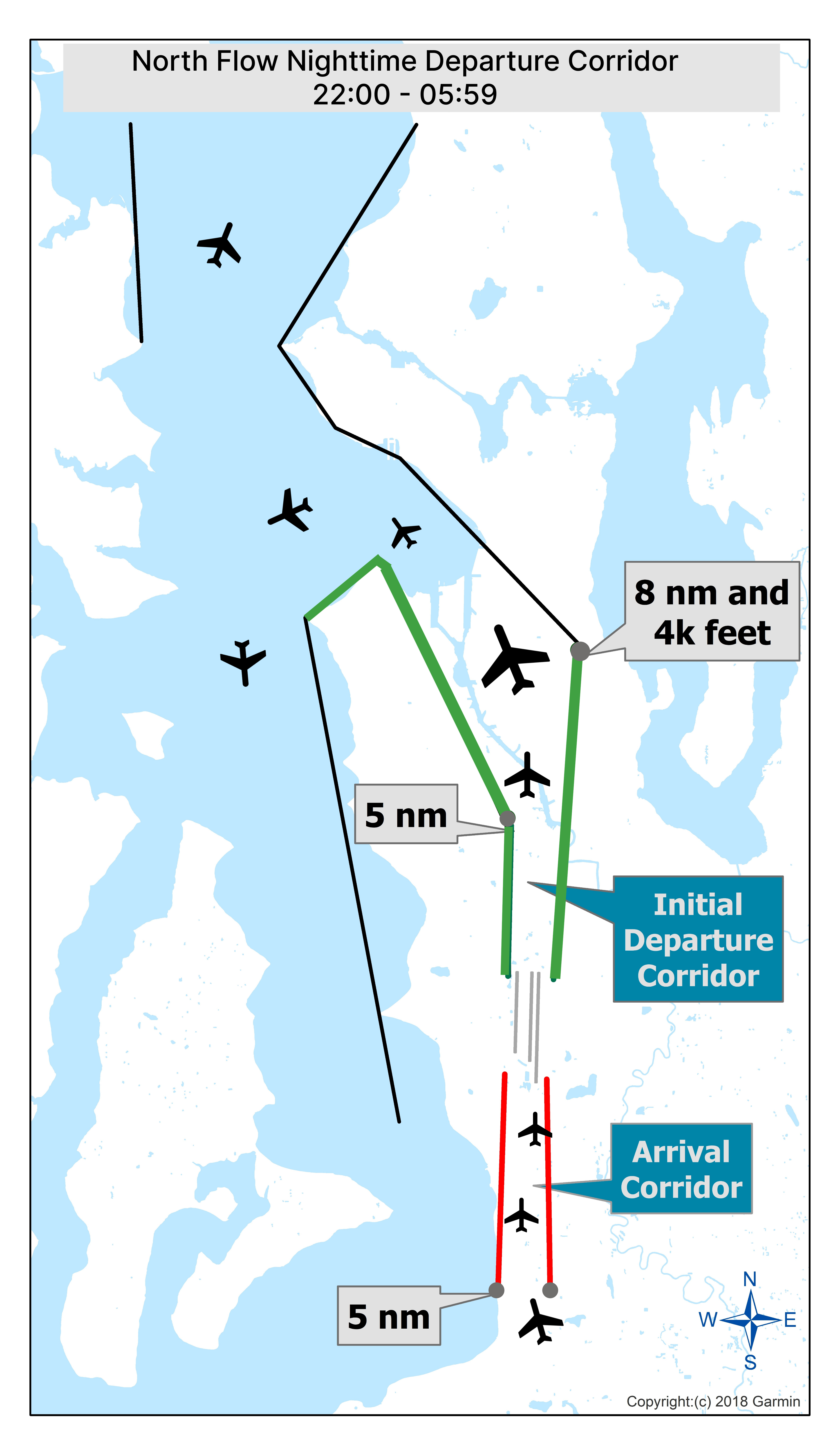
North Flows Arrivals (red), North Flows Departures - Puget Sound Procedure (green), and North Flow Departures Corridor (black)

A map titled “North Flow Nighttime Departure Corridor 22:00–05:59” showing aircraft flight paths over a coastal region with water and land areas. Several black airplane icons depict example aircraft positions. A green line marks the initial northbound departure corridor, labeled “Initial Departure Corridor,” with callouts reading “5 nm” and “8 nm and 4k feet.” A red line marks the southbound arrival corridor, labeled “Arrival Corridor,” with a “5 nm” callout near the bottom. A black line shows an alternate nighttime northbound departure routing extending west over the water. A compass rose indicating north, south, east, and west is in the lower right corner. The map is credited to Garmin (2018).

Arriving jet aircraft execute final turns before entering the narrow five nautical mile (nm) corridor extending from the runways.
Departing jet aircraft are confined to a narrow corridor and should not turn to the east. Instead, all aircraft turn to the west and continue north over the Duwamish industrial area and Elliot Bay before initiating turns towards their final destinations.  

Once through the North Flow Departures corridor, jet aircraft are then vectored toward their final destinations while over Puget Sound. Aircraft turning east must reach an altitude of at least 10,000 feet before re-crossing the shoreline.

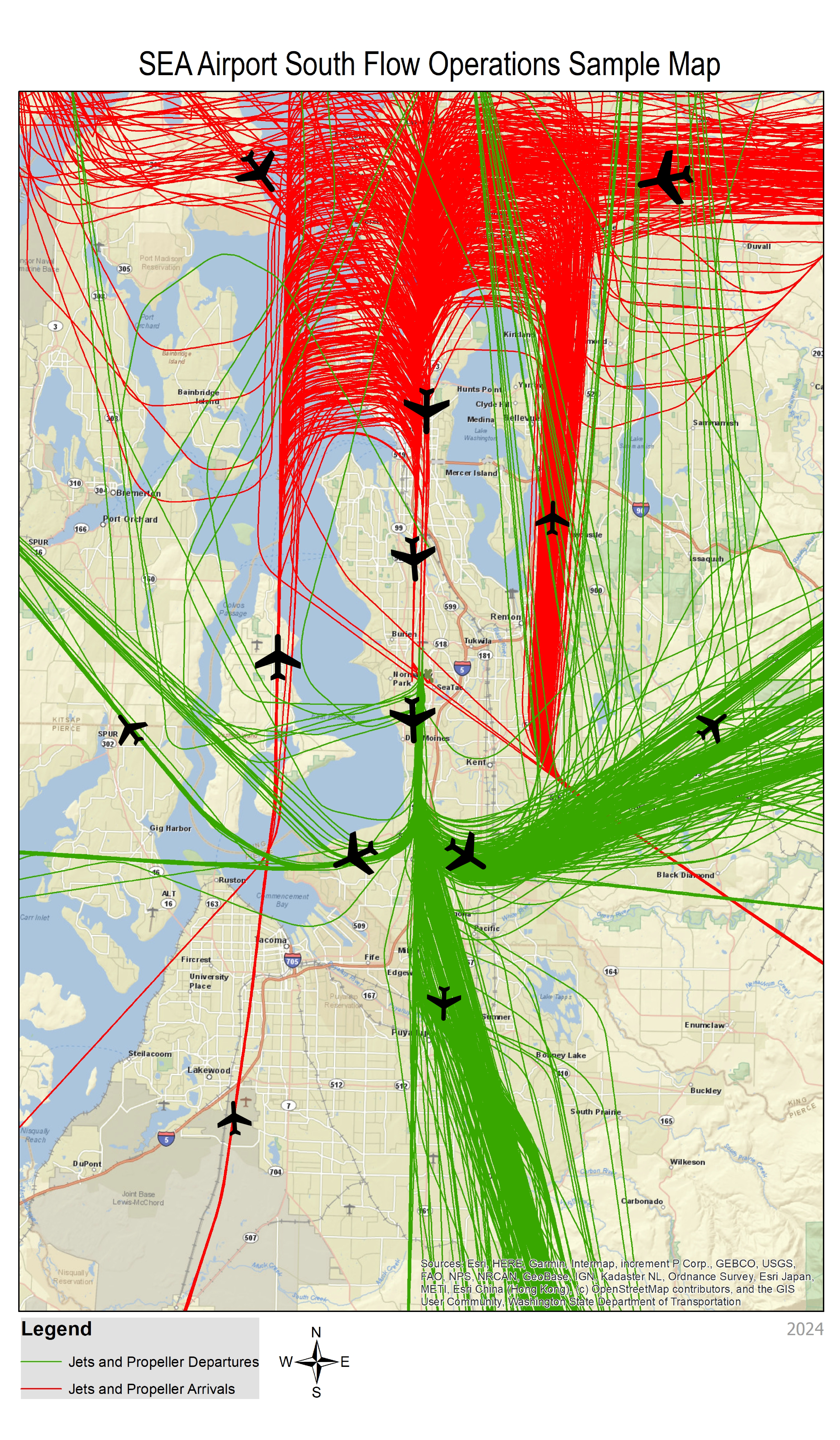
South Flow Operations Sample Flight Track Map

Winds from the south

When the winds are from the south, aircraft will depart the airport in a southerly direction and arriving aircraft will approach from the north. This operation occurs most commonly during the cooler, cloudier months of the year. The airport is in south-flow operations approximately 65 percent of the year.  

A map titled “SEA Airport South Flow Operations Sample Map” showing aircraft flight activity over the greater Seattle region. The map displays a beige‑colored base map with labeled cities, roads, and water bodies, including Puget Sound, Lake Washington, and surrounding communities. Numerous curved flight‑path lines cover the map: green lines represent jets and propeller departures, and red lines represent jets and propeller arrivals. The lines converge heavily around the airport area in the center of the map and extend in multiple directions north, south, east, and west. Black airplane icons are positioned along the various corridors to illustrate aircraft movement. A legend at the bottom identifies the meaning of the green and red lines. A compass rose appears near the bottom center showing north, south, east, west. The map is marked with “2024” in the lower right corner.


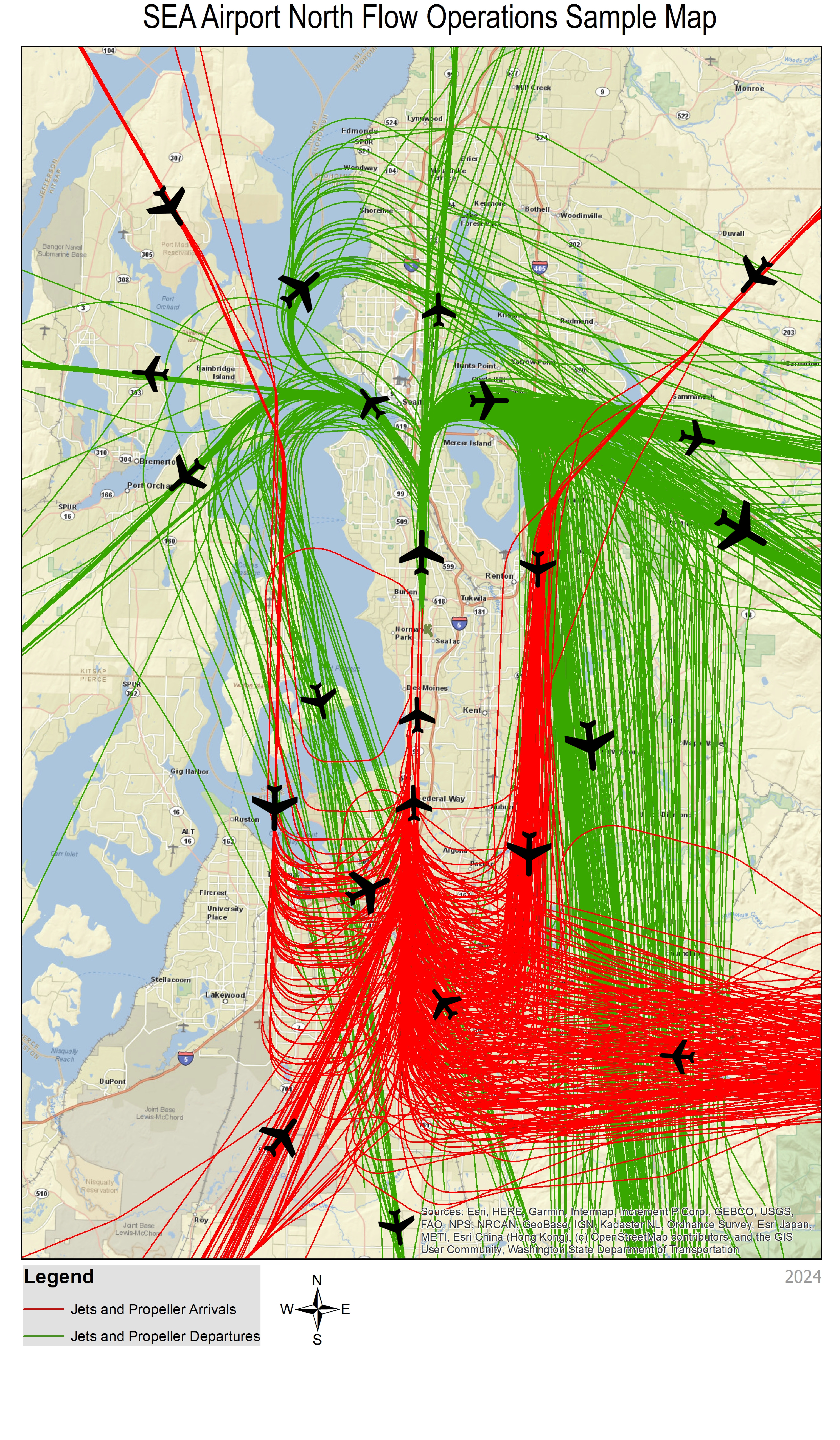
North Flow Operations Sample Flight Track Map

Winds from the north 

When winds are from the north, aircraft will depart the airport in a northerly direction and arriving aircraft will approach from the south. This operation occurs most commonly during the warmer, sunnier periods of the year.

A map titled “SEA Airport North Flow Operations Sample Map” showing aircraft flight activity over the greater Seattle region. The background is a beige‑colored map displaying cities, major roads, and waterways, including Puget Sound and Lake Washington. Numerous flight‑path lines cover the map: red lines represent jets and propeller arrivals, and green lines represent jets and propeller departures. The lines converge densely around the airport near the bottom center and extend in many directions to the north, east, and west. Black airplane icons are placed along several flight paths to illustrate aircraft movement. A legend at the bottom identifies the red and green line types, and a compass rose beneath it indicates north, south, east, and west. The bottom right corner contains the year “2024.


Related to Noise Abatement Procedures and Flight Patterns